BILLINGS, Mont. (AP) — The Yellowstone National Park area’s weather forecast the morning of June 12 seemed fairly tame: warmer temperatures and rain showers would accelerate mountain snow melt and could produce “minor flooding.” A National Weather Service bulletin recommended moving livestock from low-lying areas but made no mention of danger to people.
By nightfall, after several inches of rain fell on a deep spring snowpack, there were record-shattering floods.
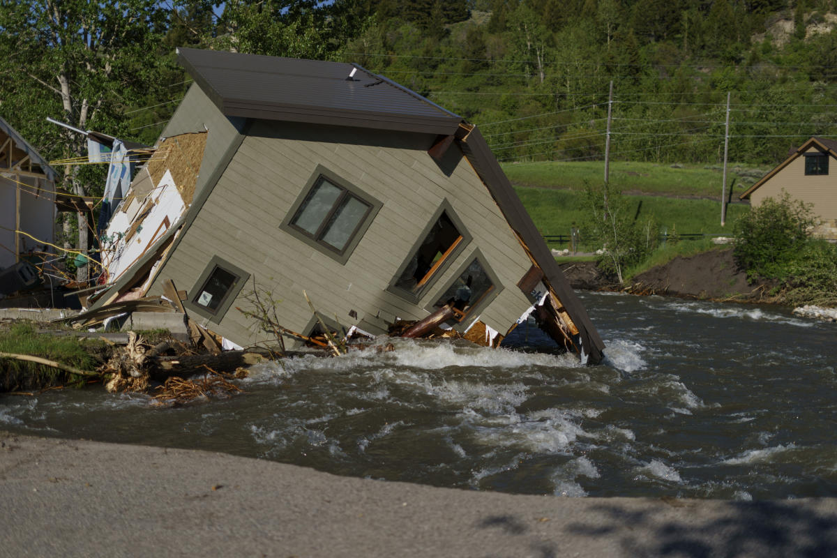
Torrents of water poured off the mountains. Swollen rivers carrying boulders and trees smashed through Montana towns over the next several days. The flooding swept away houses, wiped out bridges and forced the evacuation of more than 10,000 tourists, park employees and residents near the park.
As a cleanup expected to last months grinds on, climate experts and meteorologists say the gap between the destruction and what was forecast underscores a troublesome aspect of climate change: Models used to predict storm impacts do not always keep up with increasingly devastating rainstorms, hurricanes, heat waves and other events.
“Those rivers had never reached those levels. We literally were flying blind not even knowing what the impacts would be,” said Arin Peters, a senior hydrologist with the National Weather Service.
Hydrologic models used to predict flooding are based on long-term, historical records. But they do not reflect changes to the climate that emerged over the past decade, said meteorologist and Weather Underground founder Jeff Masters.
“Those models are going to be inadequate to deal with a new climate,” Masters said.
Another extreme weather event where the models came up short was Hurricane Ida, which slammed Louisiana last summer and then stalled over the Eastern Seaboard — deluging parts of Pennsylvania, New Jersey and New York with unprecedented rainfall that caused massive flooding.
The weather service had warned of a “serious situation” that could turn “catastrophic,” but the predicted of 3 to 6 inches (8 to 15 centimeters) of rain for New York, New Jersey and Pennsylvania was far short of the 9 to 10 inches (23 to 25 centimeters) that fell.
The deadly June 2021 heat wave that scorched the Pacific Northwest offered another example. Warmer weather had been expected, but not temperatures of up to 116 degrees (47C degrees) that toppled previous records and killed an estimated 600 or more people in Oregon, Washington state and western Canada.
The surprise Yellowstone floods prompted a nighttime scramble to close off roads and bridges getting swept away by the water, plus rushed evacuations that missed some people. No one died, somewhat miraculously, as more than 400 homes were damaged or destroyed.
As rock slides caused by the rainfall started happening in Yellowstone, park rangers closed a heavily-used road between the town of Gardiner and the park headquarters in Mammoth Hot Springs, Wyoming. It later washed out in numerous places.
The rain and snowmelt was “too much too fast and you just try to stay out of the way,” Yellowstone Deputy Chief Ranger Tim Townsend said.
If the road hadn’t been closed, “we probably would have had fatalities, unquestionably” park Superintendent Cam Sholly said.
“The road looks totally fine and then it’s like an 80-foot drop right into the river,” Sholly said.
Interior Secretary Deb Haaland was scheduled to visit Yellowstone Friday to survey the damage and ongoing repairs.
Within a matter of hours on June 12, Rock Creek, which runs through the city of Red Lodge and normally is placid and sometimes just ankle deep, became a raging river. When the weather service issued a flood warning for the creek, the water already had surged over its banks and begun to knock down bridges.
By the time the warning was sent, “we already knew it was too late,” said Scott Williams, a commissioner for Carbon County, Montana, which borders Yellowstone.
Red Lodge resident Pam Smith was alerted to the floods by something knocking around in her basement before dawn. It was her clothes dryer, floating in water pouring through the windows.
In a scramble to save keepsakes, Smith slipped on the wet kitchen floor and fell, shattering a bone in her arm. She recalled holding back tears as she trudged through floodwaters with her partner and 15-year-old granddaughter to reach their pickup truck and drive to safety.
“I went blank,” Smith said. “I was angry and like, ‘Why didn’t anybody warn us? Why was there no knock on the door? Why didn’t the police come around and say there’s flooding, you need to get out?’”
Local authorities say sheriff’s deputies and others knocked on doors in Red Lodge and a second community that flooded. But they acknowledged not everyone was reached as numerous rivers and streams overflowed, swamping areas never known previously to flood.
While no single weather event can be conclusively tied to climate change, scientists said the Yellowstone flooding was consistent with changes already documented around the park as temperatures warm.
Those changes include less snowfall in mid-winter and more spring precipitation — setting the stage for flash floods when rains fall on the snow, said Montana State University climate scientist Cathy Whitlock.
Warming trends mean spring floods will increase in frequency — even as the region suffers from long-term drought that keeps much of the rest of the year dry, she said.
Masters and other experts noted that computer modelling of storms has become more sophisticated and is generally more accurate than ever. But extreme weather by its nature is hard to predict, and as such events happen more frequently there will be many more chances for forecasters to get it wrong.
The rate of the most extreme rainstorms has increased by a factor of five, Masters said. So an event with a 1% chance of happening in any given year — commonly referred to as a “one in 100-year” event — now has a 5% chance of happening, he said.
“We are literally re-writing our weather history book,” said University of Oklahoma Meteorology Professor Jason Furtado.
That has widespread implications for local authorities and emergency officials who rely on weather bulletins to guide their disaster response approaches. If they’re not warned, they can’t act.
But the National Weather Service also strives to avoid undue alarm and maintain public trust. So if the service’s models show a only a slim chance of disaster, that information can get left out of the forecast.
Weather service officials said the agency’s actions with the Yellowstone flooding will be analyzed to determine if changes are needed. They said early warnings that river levels were rising did help officials prepare and prevent loss of life, even if their advisories failed to predict the severity.
Computer-based forecasting models are regularly updated to account for new meteorological trends due to climate change, Peters said. Even with those refinements, events like the Yellowstone flooding still are considered low-probability and so often won’t make it into forecasts based on what the models say is most likely to occur.
“It’s really difficult to balance that feeling that you’ve got that this could get really bad, but the likelihood of it getting really bad is so small,” Peters said. He added that the dramatic swing from drought to flood was hard even for meteorologists to reconcile and called it “weather whiplash.”
To better communicate the potential for extreme weather, some experts say the weather service needs to change its forecasts to inform the public about low probability hazardous events. That could be accomplished through more detailed daily forecasts or some kind of color-coded system for alerts.
“We’ve been slow to provide that information,” North Carolina State University atmospheric scientist Gary Lackmann said. “You put it on people’s radars and they could think about that and it could save lives.”
__
Hanson reported from Helena, Montana.
___
Follow Matthew Brown: @MatthewBrownAP


